Kentucky - Kenton County - Historic Districts
Kenton County Kentucky (Historic Districts) has 30 places on the National Register of Historic Places including 1 place of National significance and 4 places of Statewide significance. Significant places include Riverside Drive Historic District, Covington Downtown Commercial Historic District, Covington Downtown Commercial Historic District (Boundary Increase), Licking Riverside Historic District and Ohio Riverside Historic District (Boundary Increase).

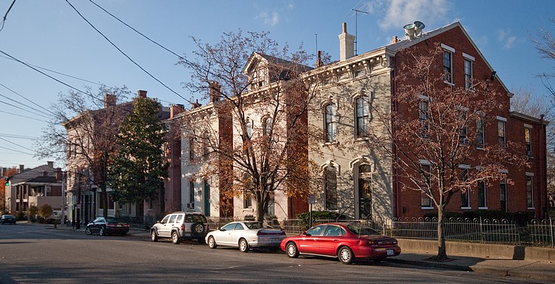
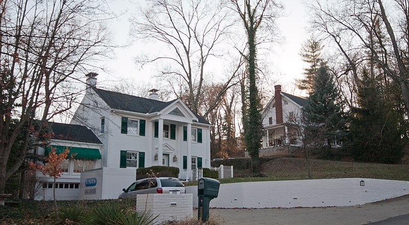
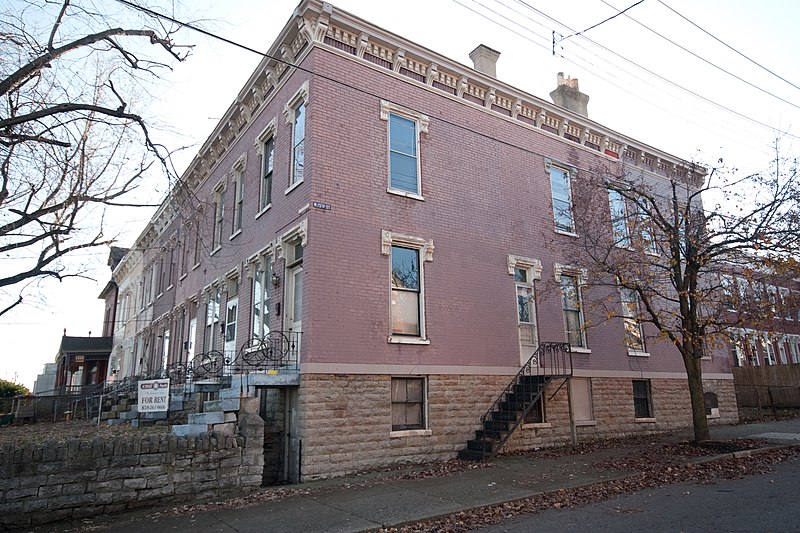
Some of the country's most noteable architects helped create the Kenton County places including Bernard T. Wisenall, Chester H. Disque, Anthony Kunz Jr., Daniel et al Seger, Weber Bros., Lyman Walker, Thomas Harlan Ellett, Walters & Stewart, Thomas J. Collopy and Kunz & Beck. Prominent architectural styles found in Kenton Country are Italianate, Bungalow/Craftsman and Colonial Revival.

Austinberg Historic District (added 1987 - - #86003483)
Roughly bounded by Chesapeake & Ohio RR, Licking River floodwall, rear lot lines N side of Wallace Ave., and Madison Ave, Covington
Nyttend, Public domain, via Wikimedia Commons
Historic Significance:
Event, Architecture/Engineering
Architect, builder, or engineer:
Walker,Lyman,et al., Hannaford,Samuel & Sons
Architectural Style:
Bungalow/Craftsman, Colonial Revival, Late Victorian
Area of Significance:
Exploration/Settlement, European, Architecture, Industry
Period of Significance:
1925-1949, 1900-1924, 1875-1899, 1850-1874
Owner:
Local, Private
Historic Function:
Commerce/Trade, Domestic, Industry/Processing/Extraction
Historic Sub-function:
Manufacturing Facility, Multiple Dwelling, Secondary Structure, Single Dwelling, Specialty Store
Current Function:
Commerce/Trade, Domestic
Current Sub-function:
Multiple Dwelling, Secondary Structure, Single Dwelling, Specialty Store
Beechwood Historic District (added 1989 - - #89001168)
Roughly bounded by Beechwood Rd., Dixie Hwy., and Woodlawn Ave. , Fort Mitchell
Nyttend, Public domain, via Wikimedia Commons
Historic Significance:
Architecture/Engineering, Event
Architect, builder, or engineer:
Unknown
Architectural Style:
Colonial Revival, Bungalow/Craftsman, Tudor Revival
Area of Significance:
Community Planning And Development, Architecture
Period of Significance:
1925-1949, 1900-1924
Owner:
Local, Private
Historic Function:
Domestic, Education
Historic Sub-function:
Multiple Dwelling, School, Single Dwelling
Current Function:
Domestic, Education
Current Sub-function:
Multiple Dwelling, School, Single Dwelling
Central Ludlow Historic District (added 1984 - - #84000526)
Roughly bounded by Glenwood, Church, Adela, and Carneal Sts. , Ludlow
Nyttend, Public domain, via Wikimedia Commons
Historic Significance:
Architecture/Engineering, Event
Architect, builder, or engineer:
multiple
Architectural Style:
Italianate, Queen Anne, Second Empire
Area of Significance:
Exploration/Settlement, Architecture, Commerce
Period of Significance:
1900-1924, 1875-1899, 1875-1899, 1850-1874
Owner:
Local, Private
Historic Function:
Commerce/Trade, Domestic
Historic Sub-function:
Business, Multiple Dwelling, Single Dwelling
Current Function:
Commerce/Trade, Domestic
Current Sub-function:
Business, Multiple Dwelling, Single Dwelling
Covington Downtown Commercial Historic District (added 1983 - - #83002804)
Also known as See Also:Covington Downtown Commercial Historic District (Bo
Roughly bounded by C & O Railroad, Robbins, Greenup and 4th Sts. , Covington
Nyttend, Public domain, via Wikimedia Commons
Historic Significance:
Event, Architecture/Engineering
Architect, builder, or engineer:
Multiple
Architectural Style:
Mixed (More Than 2 Styles From Different Periods)
Area of Significance:
Law, Commerce, Transportation, Education, Social History, Architecture, Religion
Period of Significance:
1900-1924, 1875-1899, 1850-1874, 1825-1849, 1800-1824
Owner:
Local
Historic Function:
Commerce/Trade, Domestic
Historic Sub-function:
Business, Single Dwelling, Specialty Store
Current Function:
Commerce/Trade, Domestic
Current Sub-function:
Business, Single Dwelling, Specialty Store
Covington Downtown Commercial Historic District (Boundary Increase) (added 2001 - - #01001252)
Also known as KE-C164;KE-C165;KE-C166, KE-C158-159;KE-C160;KE-C161;KE-C162;KE-C163;KE-C164;
Approx. located along Scott, Pine, and E. 8th Sts. , Covington
send us a photo to share
Historic Significance:
Event, Architecture/Engineering
Architect, builder, or engineer:
Collopy, Thomas J.
Architectural Style:
Italianate, Queen Anne
Area of Significance:
Industry, Commerce, Architecture
Period of Significance:
1950-1974, 1925-1949, 1900-1924, 1875-1899, 1850-1874
Owner:
Local, Private
Historic Function:
Commerce/Trade, Domestic, Funerary, Health Care, Industry/Processing/Extraction, Social
Historic Sub-function:
Business, Department Store, Hospital, Manufacturing Facility, Restaurant, Specialty Store
Current Function:
Commerce/Trade, Domestic, Health Care, Industry/Processing/Extraction, Vacant/Not In Use
Current Sub-function:
Business, Clinic, Manufacturing Facility, Multiple Dwelling, Professional, Restaurant
Covington Downtown Commercial Historic District (Boundary Increase) (added 1991 - - #91000457)
Also known as See Also:Covington Downtown Commercial Historic District
Roughly bounded by Ninth, Washington, and Seventh Sts. and Madison Ave. , Covington
send us a photo to share
Historic Significance:
Event, Architecture/Engineering
Architect, builder, or engineer:
Unknown
Architectural Style:
Late 19th And Early 20th Century American Movements, Modern Movement
Area of Significance:
Law, Commerce, Transportation, Education, Social History, Architecture, Religion
Period of Significance:
1900-1924, 1875-1899, 1850-1874, 1825-1849, 1800-1824
Owner:
Private
Historic Function:
Commerce/Trade, Domestic
Historic Sub-function:
Business, Single Dwelling, Specialty Store
Current Function:
Commerce/Trade, Domestic
Current Sub-function:
Business, Single Dwelling, Specialty Store
Covington Downtown Commercial Historic District (Boundary Increase) (added 1996 - - #95001525)
Also known as See Also:Covington Downtown Commercial Historic District
701, 702, 709, 711, 713, 715, 722 and 723--725 Scott Blvd. , Covington
send us a photo to share
Historic Significance:
Event, Architecture/Engineering
Architect, builder, or engineer:
et al., Ellett, Thomas Harlan
Architectural Style:
Italianate, Classical Revival, Renaissance
Area of Significance:
Commerce, Politics/Government, Architecture
Period of Significance:
1925-1949, 1900-1924, 1875-1899, 1850-1874
Owner:
Federal, Private
Historic Function:
Commerce/Trade, Domestic, Government, Health Care
Historic Sub-function:
Clinic, Courthouse, Multiple Dwelling, Post Office, Single Dwelling, Specialty Store
Current Function:
Commerce/Trade, Domestic, Government, Health Care
Current Sub-function:
Business, Clinic, Multiple Dwelling, Post Office, Specialty Store
Dixie Highway Historic District (added 1988 - - #88000146)
2696, 2698, 2700, 2708, and 2712 Dixie Hwy. , Lakeside Park
Nyttend, Public domain, via Wikimedia Commons
Historic Significance:
Architecture/Engineering
Architect, builder, or engineer:
Unknown
Architectural Style:
Bungalow/Craftsman, Other, Colonial Revival
Area of Significance:
Architecture
Period of Significance:
1900-1924
Owner:
Private
Historic Function:
Domestic, Landscape
Historic Sub-function:
Secondary Structure, Single Dwelling, Street Furniture/Object
Current Function:
Domestic, Landscape
Current Sub-function:
Secondary Structure, Single Dwelling, Street Furniture/Object
Emery--Price Historic District (added 1987 - - #86003484)
Also known as See Also:Kenton County Library
Roughly bounded by Eighth, Greenup, and Eleventh Sts., and alley behind W side of Scott Blvd. , Covington
Greg5030, CC BY-SA 3.0, via Wikimedia Commons
Historic Significance:
Event, Architecture/Engineering
Architect, builder, or engineer:
Hannaford,Samuel,et al., Craig,Randolph
Architectural Style:
Colonial Revival, Late Victorian, Greek Revival
Area of Significance:
Black, Architecture
Period of Significance:
1925-1949, 1900-1924, 1875-1899, 1850-1874, 1825-1849
Owner:
Local, Private
Historic Function:
Domestic
Historic Sub-function:
Multiple Dwelling, Single Dwelling
Current Function:
Domestic
Current Sub-function:
Multiple Dwelling, Single Dwelling
Erlanger Proper Subdivision Historic District (added 2002 - - #02000918)
Roughly bounded by by Hulbert, Division, Crescent, Dixie, and Graves. , Erlanger
Nyttend, Public domain, via Wikimedia Commons
Historic Significance:
Architecture/Engineering, Event
Architectural Style:
Italianate, Stick/Eastlake
Area of Significance:
Community Planning And Development, Architecture
Period of Significance:
1950-1974, 1925-1949, 1900-1924, 1875-1899, 1850-1874, 1825-1849, 1800-1824
Owner:
Local, Private, State
Historic Function:
Commerce/Trade, Domestic, Education, Transportation
Historic Sub-function:
Multiple Dwelling, Rail-Related, School, Single Dwelling, Specialty Store
Current Function:
Commerce/Trade, Domestic, Education, Recreation And Culture
Current Sub-function:
Museum, School, Secondary Structure, Single Dwelling, Specialty Store
Fort Mitchell Heights Historic District (added 1989 - - #89001169)
Roughly bounded by Park Rd., Barrington Rd., Dixie Hwy., and Fortside Dr. , Fort Mitchell
Nyttend, Public domain, via Wikimedia Commons
Historic Significance:
Event, Architecture/Engineering
Architect, builder, or engineer:
Unknown
Architectural Style:
Bungalow/Craftsman, Tudor Revival, Colonial Revival
Area of Significance:
Architecture, Community Planning And Development
Period of Significance:
1925-1949, 1900-1924, 1875-1899, 1850-1874
Owner:
Private
Historic Function:
Domestic
Historic Sub-function:
Multiple Dwelling, Single Dwelling
Current Function:
Domestic
Current Sub-function:
Multiple Dwelling, Single Dwelling
Helentown Historic District (added 1987 - - #86003481)
Also known as See Also:Patton,Robert,House;Cathedral Basilica of the Assum
Roughly bounded by Eleventh and Wheeler Sts., Chesapeake & Ohio RR, and Madison Blvd. , Covington
Nyttend, Public domain, via Wikimedia Commons
Historic Significance:
Event, Architecture/Engineering
Architect, builder, or engineer:
Kunz & Beck,et al., Weber Bros.
Architectural Style:
Italianate, Queen Anne, Greek Revival
Area of Significance:
Exploration/Settlement, European, Architecture
Period of Significance:
1925-1949, 1900-1924, 1875-1899, 1850-1874, 1825-1849
Owner:
Local, Private
Historic Function:
Domestic
Historic Sub-function:
Multiple Dwelling, Single Dwelling
Current Function:
Domestic
Current Sub-function:
Multiple Dwelling, Single Dwelling
Highland Cemetery Historic District (added 1989 - - #89001585)
Also known as Highland Cemetery;KEFM 150
2167 Dixie Hwy. , Fort Mitchell
RhymesWithAlbatross, CC BY-SA 3.0, via Wikimedia Commons
Historic Significance:
Architecture/Engineering
Architect, builder, or engineer:
Davis,David, Walters & Stewart
Architectural Style:
Bungalow/Craftsman
Area of Significance:
Landscape Architecture
Period of Significance:
1900-1924, 1850-1874
Owner:
Private
Historic Function:
Funerary
Historic Sub-function:
Cemetery
Current Function:
Funerary
Current Sub-function:
Cemetery
Holy Cross Church and School Complex--Latonia (added 1986 - - #86000800)
3600 blk. of Church St. , Covington
Greg5030, CC BY-SA 3.0, via Wikimedia Commons
Historic Significance:
Event, Architecture/Engineering
Architect, builder, or engineer:
Et al., Kunz,Anthony,Jr.
Architectural Style:
Other
Area of Significance:
Education, Architecture, Religion, Social History
Period of Significance:
1925-1949, 1900-1924
Owner:
Private
Historic Function:
Religion
Historic Sub-function:
Church Related Residence, Church School, Religious Structure
Current Function:
Religion
Current Sub-function:
Church Related Residence, Church School, Religious Structure
Lee--Holman Historic District (added 1996 - - #96000798)
Bounded by W. Robbins, Holman, W. 12th, and Lee Sts. , Covington
Spacini, CC BY-SA 3.0, via Wikimedia Commons
Historic Significance:
Event
Area of Significance:
Community Planning And Development
Period of Significance:
1925-1949, 1900-1924, 1875-1899, 1850-1874
Owner:
Private
Historic Function:
Commerce/Trade, Domestic
Historic Sub-function:
Multiple Dwelling, Single Dwelling, Specialty Store
Current Function:
Domestic
Current Sub-function:
Multiple Dwelling, Single Dwelling
Lewisburg Historic District (added 1993 - - #93001165)
Roughly bounded by I-75 and the Covington city limits , Covington
Nyttend, Public domain, via Wikimedia Commons
Historic Significance:
Architecture/Engineering, Event
Architect, builder, or engineer:
Multiple
Architectural Style:
Late Victorian, Greek Revival, Late 19th And 20th Century Revivals
Area of Significance:
Community Planning And Development
Period of Significance:
1925-1949, 1900-1924, 1875-1899, 1850-1874, 1825-1849
Owner:
State, Local, Private
Historic Function:
Domestic, Religion
Historic Sub-function:
Church Related Residence, Church School, Multiple Dwelling, Religious Structure, Single Dwelling
Current Function:
Domestic, Religion
Current Sub-function:
Church Related Residence, Church School, Multiple Dwelling, Religious Structure, Single Dwelling
Licking Riverside Historic District (added 1975 - - #75000787)
Also known as See Also:74000888
Roughly bounded by 4th, Scott, 8th Sts., and the Licking River , Covington
Greg5030, CC BY-SA 3.0, via Wikimedia Commons
Historic Significance:
Event, Architecture/Engineering
Architect, builder, or engineer:
Multiple
Architectural Style:
Italianate, Bungalow/Craftsman, Second Empire
Area of Significance:
Politics/Government, Education, Architecture
Period of Significance:
1900-1924, 1875-1899, 1850-1874
Owner:
Local, Private
Historic Function:
Domestic
Historic Sub-function:
Single Dwelling
Current Function:
Domestic, Social
Current Sub-function:
Multiple Dwelling, Single Dwelling
Mutter Gottes Historic District (added 1980 - - #80004499)
Also known as Mother of God Historic District;See Also:80004552
Roughly bounded by Madison Ave., 4th, Harvey, and Johnson Sts. , Covington
Greg5030, CC BY-SA 3.0, via Wikimedia Commons
Historic Significance:
Architecture/Engineering
Architect, builder, or engineer:
Multiple
Architectural Style:
No Style Listed
Area of Significance:
Architecture
Period of Significance:
1850-1874
Owner:
Local, Private
Historic Function:
Domestic
Historic Sub-function:
Multiple Dwelling, Single Dwelling
Current Function:
Domestic
Current Sub-function:
Multiple Dwelling, Single Dwelling
Mutter Gottes Historic District (Boundary Increase) (added 1980 - - #80004552)
Also known as See Also:80004499
Roughly bounded by Madison Ave., 4th, Harvey, and Johnson Sts. , Covington
send us a photo to share
Historic Significance:
Architecture/Engineering
Architect, builder, or engineer:
Multiple
Area of Significance:
Architecture
Period of Significance:
1850-1874
Owner:
Private
Historic Function:
Domestic
Historic Sub-function:
Multiple Dwelling, Single Dwelling
Current Function:
Domestic
Current Sub-function:
Multiple Dwelling, Single Dwelling
Ohio Riverside Historic District (Boundary Increase) (added 1987 - - #87000612)
Also known as See Also:Ohio Riverside Historic District
Along sections of Greenup St., Court Ave., Third, and Fourth Sts. , Covington
send us a photo to share
Historic Significance:
Architecture/Engineering, Event
Architect, builder, or engineer:
Et al., Wisenall,Bernard T.
Architectural Style:
Greek Revival, Late 19th And 20th Century Revivals, Italianate
Area of Significance:
Architecture, Exploration/Settlement, Commerce
Period of Significance:
1900-1924, 1875-1899, 1850-1874, 1825-1849
Owner:
Private
Historic Function:
Commerce/Trade, Domestic
Historic Sub-function:
Business, Multiple Dwelling, Single Dwelling, Specialty Store
Current Function:
Commerce/Trade, Domestic
Current Sub-function:
Business, Multiple Dwelling, Single Dwelling, Specialty Store
Old Fort Mitchell Historic District (added 1989 - - #89001170)
Roughly bounded by Saint Johns Rd., Dixie Hwy., E. Maple Ave., and Edgewood Rd. , Fort Mitchell
Nyttend, Public domain, via Wikimedia Commons
Historic Significance:
Event, Architecture/Engineering
Architect, builder, or engineer:
Unknown
Architectural Style:
Bungalow/Craftsman, Tudor Revival, Colonial Revival
Area of Significance:
Architecture, Community Planning And Development
Period of Significance:
1925-1949, 1900-1924
Owner:
Private
Historic Function:
Domestic
Historic Sub-function:
Multiple Dwelling, Single Dwelling
Current Function:
Commerce/Trade, Domestic
Current Sub-function:
Multiple Dwelling, Professional, Single Dwelling
Park Hills Historic District (added 2008 - - #07001252)
Roughly bounded by Dixie Hwy., Montague, Breckenridge, Sleepy Hollow Rds., Old State, Arlington Rds., St. James Ave , Park Hills
Greg5030, CC BY-SA 3.0, via Wikimedia Commons
Historic Significance:
Architecture/Engineering, Event
Architectural Style:
Late 19th And 20th Century Revivals, Late 19th And Early 20th Century American Movements
Area of Significance:
Community Planning And Development, Architecture
Period of Significance:
1950-1974, 1925-1949
Owner:
Private, Local
Historic Function:
Domestic, Landscape, Religion, Transportation
Historic Sub-function:
Religious Structure, Road-Related, Road-Related, Secondary Structure, Single Dwelling, Unoccupied Land
Current Function:
Domestic, Landscape, Religion, Transportation
Current Sub-function:
Rail-Related, Religious Structure, Road-Related, Secondary Structure, Single Dwelling, Unoccupied Land
Ritte's Corner Historic District, Latonia (added 1987 - - #87000776)
Also known as Ritte's Corner
Roughly bounded by DeCoursey, Southern, Inez, and Winston Aves. , Covington
Greg5030, CC BY-SA 3.0, via Wikimedia Commons
Historic Significance:
Event, Architecture/Engineering
Architect, builder, or engineer:
Disque,Chester H.
Architectural Style:
Bungalow/Craftsman, Classical Revival, Italianate
Area of Significance:
Architecture, Commerce, Transportation
Period of Significance:
1925-1949, 1900-1924, 1875-1899
Owner:
Private
Historic Function:
Commerce/Trade, Domestic
Historic Sub-function:
Business, Single Dwelling, Specialty Store
Current Function:
Commerce/Trade, Domestic
Current Sub-function:
Business, Single Dwelling, Specialty Store
Ritte's Corner Historic District, Latonia (Boundary Increase) (added 2001 - - #00001598)
Also known as KECT2, 3, 4, 5, 6, 7, 7.1, 8, 8.1, 9, 10, 10.1, 11
Approx. 3424-3601 Decoursey Ave., 9 E. Southern Ave. and CSX Railroad Property , Covington
send us a photo to share
Historic Significance:
Event, Architecture/Engineering
Architectural Style:
Late Victorian, Late 19th And 20th Century Revivals
Area of Significance:
Commerce, Transportation
Period of Significance:
1950-1974, 1925-1949, 1900-1924, 1875-1899
Owner:
Private, State
Historic Function:
Commerce/Trade, Domestic, Industry/Processing/Extraction, Landscape, Transportation
Historic Sub-function:
Business, Energy Facility, Garden, Multiple Dwelling, Rail-Related, Single Dwelling, Specialty Store
Current Function:
Commerce/Trade, Domestic, Industry/Processing/Extraction, Transportation, Vacant/Not In Use
Current Sub-function:
Business, Department Store, Energy Facility, Multiple Dwelling, Rail-Related, Single Dwelling, Specialty Store
Riverside Drive Historic District (added 1971 - - #71000350)
Also known as See Also:Beard, Daniel C., House;Ohio Riverside Historic Dis
Bounded by Riverside Dr., 4th St., Licking River, and the alley between Greenup and Garrard Sts. , Covington
Nyttend, Public domain, via Wikimedia Commons
Historic Significance:
Architecture/Engineering
Architect, builder, or engineer:
Unknown
Architectural Style:
Georgian, Late Victorian, Greek Revival
Area of Significance:
Architecture
Period of Significance:
1875-1899, 1850-1874, 1825-1849, 1800-1824
Owner:
Local, Private
Historic Function:
Domestic
Historic Sub-function:
Single Dwelling
Current Function:
Domestic
Current Sub-function:
Single Dwelling
Seminary Square Historic District (added 1980 - - #80001647)
Roughly bounded by RR tracks, Holman, 9th and 12th Sts. , Covington
Spacini, CC BY-SA 3.0, via Wikimedia Commons
Historic Significance:
Event, Architecture/Engineering
Architect, builder, or engineer:
Unknown
Architectural Style:
Federal, Second Empire, Italianate
Area of Significance:
Education, Religion, Architecture
Period of Significance:
1900-1924, 1875-1899, 1850-1874, 1825-1849, 1800-1824
Owner:
Private
Historic Function:
Domestic, Religion
Historic Sub-function:
Single Dwelling
Current Function:
Domestic, Religion
Current Sub-function:
Single Dwelling
Wallace Woods Area Residential Historic District (added 1983 - - #83002807)
Roughly bounded by 24th St., Glenway, Wallace, and Madison Aves. , Covington
Greg5030, CC BY-SA 3.0, via Wikimedia Commons
Historic Significance:
Event, Architecture/Engineering
Architect, builder, or engineer:
Multiple
Architectural Style:
Mixed (More Than 2 Styles From Different Periods)
Area of Significance:
Architecture, Commerce
Period of Significance:
1900-1924, 1875-1899, 1850-1874, 1825-1849
Owner:
Private
Historic Function:
Commerce/Trade, Domestic
Historic Sub-function:
Multiple Dwelling, Single Dwelling
Current Function:
Commerce/Trade, Domestic
Current Sub-function:
Multiple Dwelling, Single Dwelling
West Fifteenth Street Historic District (added 1987 - - #86003485)
1445--1451 and 1501--1513 Madison Ave., 1421-1423 Neave St., and 10--32 W. Fifteenth St. , Covington
Slick-o-bot, CC BY-SA 3.0, via Wikimedia Commons
Historic Significance:
Architecture/Engineering
Architect, builder, or engineer:
Unknown
Architectural Style:
Italianate, Queen Anne
Area of Significance:
Architecture
Period of Significance:
1900-1924, 1875-1899
Owner:
Private
Historic Function:
Domestic
Historic Sub-function:
Multiple Dwelling, Single Dwelling
Current Function:
Domestic
Current Sub-function:
Multiple Dwelling, Single Dwelling
West Side-Main Strasse Historic District (added 1983 - - #83003650)
Also known as West Side-Main Strasse
Roughly bounded by C&0 Railroad, 6th, Philadelphia, Dalton, Pike, and Robbins Sts. , Covington
Greg5030, CC BY-SA 3.0, via Wikimedia Commons
Historic Significance:
Event, Architecture/Engineering
Architect, builder, or engineer:
Seger,Daniel et al
Architectural Style:
Italianate, Late Victorian
Area of Significance:
Education, Architecture, Commerce, Industry, Social History, Religion
Period of Significance:
1875-1899, 1850-1874, 1825-1849
Owner:
Private
Historic Function:
Commerce/Trade, Domestic
Historic Sub-function:
Single Dwelling, Specialty Store
Current Function:
Commerce/Trade, Domestic
Current Sub-function:
Single Dwelling, Specialty Store
Yeager, William A., and Edward Mohr Farmstead (added 1994 - - #94001380)
5002 Madison Pike , Independence
send us a photo to share
Historic Significance:
Event
Area of Significance:
Agriculture
Period of Significance:
1925-1949, 1900-1924
Owner:
Private
Historic Function:
Agriculture/Subsistence
Current Function:
Agriculture/Subsistence
Return to Top
Select a Different Kentucky County (map)
Adair
Allen
Anderson
Ballard
Barren
Bath
Bell
Boone
Bourbon
Boyd
Boyle
Bracken
Breathitt
Breckinridge
Bullitt
Butler
Caldwell
Calloway
Campbell
Carroll
Casey
Christian
Clark
Clay
Cumberland
Daviess
Edmonson
Estill
Fayette
Fleming
Floyd
Franklin
Fulton
Gallatin
Garrard
Graves
Grayson
Green
Greenup
Hancock
Hardin
Harlan
Harrison
Hart
Henderson
Henry
Hopkins
Jackson
Jefferson
Jessamine
Kenton
Knott
Knox
Larue
Laurel
Lawrence
Leslie
Letcher
Lewis
Lincoln
Livingston
Logan
Lyon
Madison
Marion
Marshall
Mason
McCracken
McCreary
Meade
Menifee
Mercer
Metcalfe
Montgomery
Muhlenberg
Nelson
Nicholas
Ohio
Oldham
Owen
Pendleton
Pike
Powell
Pulaski
Rockcastle
Rowan
Scott
Shelby
Simpson
Spencer
Taylor
Todd
Trigg
Trimble
Union
Warren
Washington
Wayne
Webster
Whitley
Woodford
Select a Different State (map)
Alabama
Alaska
Arizona
Arkansas
California
Colorado
Connecticut
Delaware
District Of Columbia
Florida
Georgia
Hawaii
Idaho
Illinois
Indiana
Iowa
Kansas
Kentucky
Louisiana
Maine
Maryland
Massachusetts
Michigan
Minnesota
Mississippi
Missouri
Montana
Nebraska
Nevada
New Hampshire
New Jersey
New Mexico
New York
North Carolina
North Dakota
Ohio
Oklahoma
Oregon
Pennsylvania
Rhode Island
South Carolina
South Dakota
Tennessee
Texas
Utah
Vermont
Virginia
Washington
West Virginia
Wisconsin
Wyoming
Return to Home Page