New Jersey - Somerset County - Historic Districts
Somerset County New Jersey (Historic Districts) has 30 places on the National Register of Historic Places including 2 places of Statewide significance. Significant places include Clover Hill Historic District and Delaware and Raritan Canal, Basking Ridge Historic District, Blawenburg Historic District and Bridgepoint Historic District.

Several famous people are associated with these Somerset County historic places including HEnry Greenland, Kennedy, Samuel and Rev.

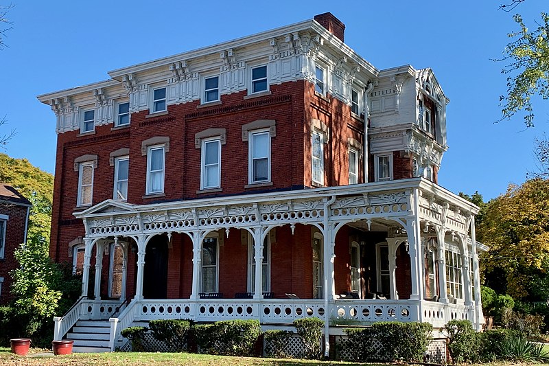
Some of the country's most noteable architects helped create the Somerset County places including George B. Post, William Kirk, Charles H. Smith, James A. Goltra and Thomas Kirkpatrick. Prominent architectural styles found in Somerset Country are Greek Revival, Late Victorian and Federal.

Basking Ridge Historic District (added 1994 - - #94000817)
Also known as Basking Ridge;See Also:Presbyterian Church in Basking Ridge;
Roughly, along N. and S. Finley Aves., N. and S. Maple Aves. and Lewis Craig and Oak Sts., Bernards Township , Basking Ridge
send us a photo to share
Historic Significance:
Event, Architecture/Engineering
Architect, builder, or engineer:
Kirkpatrick, Thomas, Kirk, William
Architectural Style:
Mid 19th Century Revival, Late Victorian
Area of Significance:
Architecture, Agriculture, Community Planning And Development, Education
Period of Significance:
1925-1949, 1900-1924, 1875-1899, 1850-1874, 1825-1849, 1800-1824
Owner:
Private, Local
Historic Function:
Commerce/Trade, Domestic, Government, Religion
Historic Sub-function:
Department Store, Hotel, Professional, Religious Structure, Restaurant, Single Dwelling
Current Function:
Commerce/Trade, Domestic, Government, Religion
Current Sub-function:
Business, City Hall, Professional, Religious Structure, Restaurant, Single Dwelling
Blawenburg Historic District (added 1990 - - #88000632)
Also known as See Also:Reformed Dutch Church of Blawenburg
Georgetown--Franklin Tpk./CR 588, Great Rd./CR 601, and Mountain View Rd. , Blawenburg
Zeete, CC BY-SA 4.0, via Wikimedia Commons
Historic Significance:
Architecture/Engineering, Event
Architect, builder, or engineer:
Multiple
Architectural Style:
Mid 19th Century Revival, Colonial Revival, Late Victorian
Area of Significance:
Exploration/Settlement, Agriculture, Religion, Architecture
Period of Significance:
1925-1949, 1900-1924, 1875-1899, 1850-1874, 1825-1849, 1800-1824
Owner:
Private, State, Local
Historic Function:
Commerce/Trade, Domestic
Historic Sub-function:
Single Dwelling
Current Function:
Agriculture/Subsistence, Commerce/Trade, Domestic, Education, Government, Religion
Bridgepoint Historic District (added 1975 - - #75001161)
N of Rocky Hill off U.S. 206 , Rocky Hill
Jaggabao, CC BY-SA 4.0, via Wikimedia Commons
Historic Significance:
Event, Architecture/Engineering
Architect, builder, or engineer:
Unknown
Architectural Style:
Other, Georgian, Late Victorian
Area of Significance:
Agriculture, Architecture, Commerce
Period of Significance:
1850-1874, 1700-1749
Owner:
Private, Local
Historic Function:
Agriculture/Subsistence, Domestic, Industry/Processing/Extraction
Historic Sub-function:
Single Dwelling
Current Function:
Agriculture/Subsistence, Domestic
Current Sub-function:
Single Dwelling
Clover Hill Historic District (added 1980 - - #80002492)
Also known as Clover Hill
Amwell and Wertsville-Clover Hill Rds. , Montgomery
Zeete, CC BY-SA 4.0, via Wikimedia Commons
Historic Significance:
Event
Area of Significance:
Religion, Exploration/Settlement
Period of Significance:
1875-1899, 1850-1874, 1825-1849
Owner:
Private
Historic Function:
Domestic, Religion
Historic Sub-function:
Religious Structure, Single Dwelling
Current Function:
Domestic, Religion
Current Sub-function:
Religious Structure, Single Dwelling
Delaware and Raritan Canal (added 1973 - - #73001105)
Follows the Delaware River to Trenton, then E to New Brunswick , Somerville
Zeete, CC BY-SA 3.0, via Wikimedia Commons
Historic Significance:
Event, Architecture/Engineering
Architect, builder, or engineer:
Unknown
Architectural Style:
No Style Listed
Area of Significance:
Transportation, Engineering, Commerce
Period of Significance:
1900-1924, 1875-1899, 1850-1874, 1825-1849
Owner:
State
Historic Function:
Domestic, Transportation
Historic Sub-function:
Single Dwelling, Water-Related
Current Function:
Domestic, Landscape
Current Sub-function:
Park, Single Dwelling
East Millstone Historic District (added 1983 - - #83001613)
Amwell Rd. and Delaware & Raritan Canal , East Millstone
Zeete, CC BY-SA 4.0, via Wikimedia Commons
Historic Significance:
Event, Architecture/Engineering
Architectural Style:
Greek Revival, Federal, Late Victorian
Area of Significance:
Architecture, Commerce, Transportation, Industry
Period of Significance:
1850-1874, 1825-1849
Owner:
Private
Historic Function:
Domestic, Industry/Processing/Extraction, Transportation
Historic Sub-function:
Manufacturing Facility, Road-Related, Single Dwelling, Water-Related
Current Function:
Commerce/Trade, Domestic, Religion
Current Sub-function:
Single Dwelling
Franklin Corners Historic District (added 1975 - - #75001159)
N of Bernardsville on Hardscrabble and Childs Rds. and U.S. 202 , Bernardsville
Zeete, CC BY-SA 4.0, via Wikimedia Commons
Historic Significance:
Event, Architecture/Engineering
Architect, builder, or engineer:
Unknown
Architectural Style:
Greek Revival
Area of Significance:
Commerce, Education, Industry, Architecture
Period of Significance:
1875-1899, 1850-1874, 1825-1849, 1800-1824, 1750-1799
Owner:
Private
Historic Function:
Agriculture/Subsistence, Commerce/Trade, Domestic, Education, Industry/Processing/Extraction
Historic Sub-function:
Department Store, Manufacturing Facility, School, Single Dwelling
Current Function:
Domestic, Vacant/Not In Use
Current Sub-function:
Single Dwelling
Griggstown Historic District (added 1984 - - #84002798)
Roughly Canal Rd. from Old Georgetown Rd. to Ten Mile Run , Griggstown
Zeete, CC BY-SA 4.0, via Wikimedia Commons
Historic Significance:
Event, Architecture/Engineering
Architect, builder, or engineer:
Unknown
Architectural Style:
Greek Revival, Federal
Area of Significance:
Transportation, Industry, Agriculture, Architecture, Commerce
Period of Significance:
1900-1924, 1850-1874, 1825-1849, 1750-1799, 1700-1749
Owner:
Private, Local
Historic Function:
Agriculture/Subsistence, Domestic, Industry/Processing/Extraction
Historic Sub-function:
Agricultural Fields, Manufacturing Facility, Single Dwelling
Current Function:
Commerce/Trade, Domestic
Current Sub-function:
Single Dwelling
Kennedy--Martin--Stelle Farmstead (added 2004 - - #03000868)
450 King George Rd. , Bernards Township (Basking Ridge)
Jaggabao, CC BY-SA 4.0, via Wikimedia Commons
Historic Significance:
Architecture/Engineering, Person
Architectural Style:
Colonial
Historic Person:
Kennedy, Samuel, Rev
Owner:
Private
Historic Function:
Agriculture/Subsistence, Domestic
Historic Sub-function:
Agricultural Outbuildings, Animal Facility, Single Dwelling, Storage
Current Function:
Vacant/Not In Use
Kingston Mill Historic District (added 1986 - - #86000707)
Roughly bounded by Herrontown, River, Princeton-Kingston Rds., and lots W of Princeton Twp. , Franklin
Zeete, CC BY-SA 4.0, via Wikimedia Commons
Historic Significance:
Event, Person, Architecture/Engineering
Architect, builder, or engineer:
Unknown
Architectural Style:
Federal, Colonial, Late Victorian
Historic Person:
Greenland,HEnry
Area of Significance:
Exploration/Settlement, Engineering, Transportation, Industry
Period of Significance:
1875-1899, 1850-1874, 1825-1849, 1800-1824, 1750-1799, 1700-1749, 1650-1699
Owner:
Private, Local
Historic Function:
Agriculture/Subsistence, Domestic, Industry/Processing/Extraction
Historic Sub-function:
Agricultural Outbuildings, Manufacturing Facility, Secondary Structure, Single Dwelling
Current Function:
Agriculture/Subsistence, Domestic
Current Sub-function:
Agricultural Outbuildings, Single Dwelling
Kingston Village Historic District (added 1990 - - #89002163)
Also known as Kingstown
Roughly NJ 27 from Raymond Rd. to Delaware & Raritan Canal, Church St., Laurel Ave., Heathcote Brook Rd., & Academy St. , Kingston
KLOTZ, CC BY-SA 3.0, via Wikimedia Commons
Historic Significance:
Architecture/Engineering, Event
Architect, builder, or engineer:
Unknown
Architectural Style:
Greek Revival, Late Victorian, Colonial
Area of Significance:
Commerce, Transportation, Exploration/Settlement, Architecture, Religion
Period of Significance:
1925-1949, 1900-1924, 1900-1750 AD, 1700-1749
Owner:
State, Private, Local
Historic Function:
Agriculture/Subsistence, Commerce/Trade, Domestic, Education, Funerary, Religion, Transportation
Historic Sub-function:
Cemetery, Religious Structure, Single Dwelling
Current Function:
Commerce/Trade, Domestic, Religion
Current Sub-function:
Religious Structure, Single Dwelling, Specialty Store
Lamington Historic District (added 1984 - - #84002802)
Lamington, Black River, Rattlesnake Bridge, and Cowperthwaite Rds. , Lamington
Zeete, CC BY-SA 4.0, via Wikimedia Commons
Historic Significance:
Architecture/Engineering, Event
Architect, builder, or engineer:
Unknown
Architectural Style:
Greek Revival, Queen Anne
Area of Significance:
Exploration/Settlement, Architecture, Religion
Period of Significance:
1900-1750 AD
Owner:
Private, Local
Historic Function:
Domestic, Religion
Historic Sub-function:
Religious Structure, Single Dwelling
Current Function:
Domestic, Religion
Current Sub-function:
Religious Structure, Single Dwelling
Liberty Corner Historic District (added 1991 - - #91001477)
Also known as Liberty Corner
Roughly, jct. of Church St. and Valley and Lyons Rds., and area W and SW, Bernards Township , Liberty Corner
Zeete, CC BY-SA 4.0, via Wikimedia Commons
Historic Significance:
Event, Architecture/Engineering
Architect, builder, or engineer:
Goltra,James A.
Architectural Style:
Colonial Revival, Queen Anne, Italianate
Area of Significance:
Community Planning And Development, Architecture
Period of Significance:
1925-1949, 1900-1924, 1875-1899, 1850-1874
Owner:
Private
Historic Function:
Agriculture/Subsistence, Domestic, Religion
Historic Sub-function:
Agricultural Fields, Agricultural Outbuildings, Animal Facility, Religious Structure, Single Dwelling
Current Function:
Agriculture/Subsistence, Domestic, Religion
Current Sub-function:
Agricultural Fields, Agricultural Outbuildings, Animal Facility, Religious Structure, Single Dwelling
Lyons Veterans Administration Hospital Historic District (added 2013 - - #13000461)
151 Knollcroft Rd., Lyons
Zeete, CC BY-SA 4.0, via Wikimedia Commons
Historic Significance:
Event, Architecture/Engineering
Architectural Style:
Colonial Revival, Classical Revival
Area of Significance:
Politics/Government, Health/Medicine, Architecture
Period of Significance:
1950-1974, 1925-1949
Middlebush Village Historic District (added 2007 - - #07000354)
Amwell Rd., S. Middlebush Rd., Railroad Ave., Olcott St., and Debow St. , Franklin
Zeete, CC BY-SA 4.0, via Wikimedia Commons
Historic Significance:
Event, Architecture/Engineering
Architectural Style:
Colonial Revival, Greek Revival
Area of Significance:
Community Planning And Development
Period of Significance:
1925-1949, 1900-1924, 1875-1899, 1850-1874, 1825-1849
Owner:
Private, Local
Historic Function:
Domestic, Education, Religion
Historic Sub-function:
Religious Structure, School, Single Dwelling
Current Function:
Commerce/Trade, Domestic, Education, Government, Religion
Current Sub-function:
City Hall, Religious Structure, Restaurant, School, Single Dwelling
Millstone Historic District (added 1976 - - #76001188)
Amwell and River Rds. , Millstone
Zeete, CC BY-SA 4.0, via Wikimedia Commons
Historic Significance:
Event
Area of Significance:
Military
Period of Significance:
1850-1874, 1750-1799, 1700-1749
Owner:
Private, Local
Historic Function:
Commerce/Trade, Domestic
Historic Sub-function:
Business, Restaurant, Single Dwelling, Specialty Store, Warehouse
Current Function:
Commerce/Trade, Domestic, Recreation And Culture
Current Sub-function:
Outdoor Recreation, Single Dwelling
Millstone Valley Agricultural District (added 1977 - - #77000907)
S of Millstone on River Rd. , Millstone
Zeete, CC BY-SA 4.0, via Wikimedia Commons
Historic Significance:
Event
Area of Significance:
Agriculture
Period of Significance:
1900-1924, 1875-1899, 1850-1874, 1825-1849
Owner:
Private
Historic Function:
Agriculture/Subsistence, Domestic
Historic Sub-function:
Agricultural Outbuildings, Animal Facility, Processing, Single Dwelling, Storage
Current Function:
Agriculture/Subsistence, Domestic
Current Sub-function:
Agricultural Outbuildings, Animal Facility, Processing, Single Dwelling, Storage
Neshanic Historic District (added 1979 - - #79001519)
Also known as See Also:Neshanic Mills
Amwell and Zion Rds , Neshanic
Zeete, CC BY-SA 4.0, via Wikimedia Commons
Historic Significance:
Event
Area of Significance:
Exploration/Settlement, Religion
Period of Significance:
1900-1924, 1875-1899, 1850-1874, 1825-1849, 1800-1824, 1750-1799
Owner:
Private
Historic Function:
Domestic
Historic Sub-function:
Single Dwelling
Current Function:
Domestic
Current Sub-function:
Single Dwelling
Neshanic Mills (added 1978 - - #78001797)
Main Rd. and Mill Lane , Neshanic
Zeete, CC BY-SA 4.0, via Wikimedia Commons
Historic Significance:
Event, Architecture/Engineering
Architect, builder, or engineer:
Unknown
Architectural Style:
No Style Listed, Other
Area of Significance:
Transportation, Engineering, Industry, Social History
Period of Significance:
1900-1924, 1875-1899, 1850-1874, 1825-1849
Owner:
Private, Local
Historic Function:
Agriculture/Subsistence, Domestic, Industry/Processing/Extraction, Transportation
Historic Sub-function:
Agricultural Outbuildings, Manufacturing Facility, Rail-Related, Road-Related, Single Dwelling
Current Function:
Transportation, Work In Progress
Neshanic Station Historic District (added 2016 - - #15001051)
Branchburg Township, Branchburg Township
Zeete, CC BY-SA 4.0, via Wikimedia Commons
Historic Significance:
Event, Person, Architecture/Engineering
Architectural Style:
Italian Villa, Gothic Revival
Historic Person:
Schenuck, John G.
Area of Significance:
Community Planning And Development
Period of Significance:
1850-1949 AD
North Branch Historic District (added 2012 - - #12000209)
Easton Tpk., Vanderveer Ave., Burnt Mills, & Station Rds. (Branchburg Township), North Branch
Zeete, CC BY-SA 4.0, via Wikimedia Commons
Historic Significance:
Event, Architecture/Engineering
Architectural Style:
Colonial, Federal
Area of Significance:
Architecture, Community Planning And Development
Period of Significance:
1900-1924, 1875-1899, 1850-1874, 1825-1849, 1800-1824, 1750-1799, 1700-1749
Olcott Avenue Histrict District (added 2009 - - #09000940)
Portions of Olcott, Childsworth, and Highview Avenues, and Church St. , Bernardsville Borough
Zeete, CC BY-SA 4.0, via Wikimedia Commons
Historic Significance:
Architecture/Engineering, Event
Architect, builder, or engineer:
Post, George B., et al.
Architectural Style:
Colonial Revival, Tudor Revival
Area of Significance:
Community Planning And Development, Education, Architecture
Period of Significance:
1925-1949, 1900-1924, 1875-1899
Owner:
Local, Private
Historic Function:
Domestic, Domestic, Education, Religion, Religion, Social
Historic Sub-function:
Church Related Residence, Civic, Religious Structure, School, Secondary Structure, Single Dwelling
Current Function:
Domestic, Domestic, Education, Religion, Religion
Current Sub-function:
Church Related Residence, Religious Structure, School, Secondary Structure, Single Dwelling
Pluckemin Village Historic District (added 1982 - - #82003303)
US 206 and Burnt Mills Rd. , Bedminster
Zeete, CC BY-SA 4.0, via Wikimedia Commons
Historic Significance:
Event, Architecture/Engineering
Architect, builder, or engineer:
Unknown
Architectural Style:
Georgian, Italianate, Greek Revival
Area of Significance:
Architecture, Commerce, Religion
Period of Significance:
1900-1924, 1875-1899, 1850-1874, 1825-1849, 1750-1799, 1750-1799
Owner:
Private, Local
Historic Function:
Commerce/Trade, Domestic
Historic Sub-function:
Single Dwelling
Current Function:
Commerce/Trade, Domestic
Current Sub-function:
Business, Single Dwelling, Specialty Store
Pottersville Village Historic District (added 1990 - - #90001475)
Also known as Potter's Mills;Pottersville
Properties fronting on Black River, Pottersville, McCann Mill and Hacklebarney Rds. and Fairmount Rd. E and Hill St. , Pottersville
Zeete, CC BY-SA 4.0, via Wikimedia Commons
Historic Significance:
Information Potential, Architecture/Engineering, Event
Architect, builder, or engineer:
Unknown
Architectural Style:
Other, Italianate, Queen Anne
Area of Significance:
Historic - Non-Aboriginal, Commerce, Exploration/Settlement, Industry, Architecture
Cultural Affiliation:
Rural American
Period of Significance:
1900-1924, 1875-1899, 1850-1874, 1825-1849, 1800-1824, 1750-1799
Owner:
Private, State
Historic Function:
Agriculture/Subsistence, Domestic, Industry/Processing/Extraction, Religion
Historic Sub-function:
Hotel, Manufacturing Facility, Processing, Religious Structure, Single Dwelling, Water Works
Current Function:
Commerce/Trade, Domestic, Education, Religion
Current Sub-function:
Business, Department Store, Financial Institution, Religious Structure, School, Single Dwelling
River Road Historic Rural District (added 1991 - - #91000256)
Also known as Millstone River
Millstone River Rd. from Hillsborough Rd. to Van Horne Rd., Hillsborough and Montgomery Townships , Griggstown
Zeete, CC BY-SA 4.0, via Wikimedia Commons
Historic Significance:
Event, Architecture/Engineering
Architect, builder, or engineer:
Unknown
Architectural Style:
Late Victorian, Federal, Colonial
Area of Significance:
Transportation, Exploration/Settlement, Architecture
Period of Significance:
1925-1949, 1900-1924, 1875-1899, 1850-1874, 1825-1849, 1800-1824, 1750-1799, 1700-1749
Owner:
State, Private, Local
Historic Function:
Agriculture/Subsistence, Domestic, Education, Funerary, Transportation
Historic Sub-function:
Cemetery, Road-Related, School, Single Dwelling, Water-Related
Current Function:
Agriculture/Subsistence, Domestic, Funerary, Transportation
Current Sub-function:
Agricultural Fields, Agricultural Outbuildings, Animal Facility, Cemetery, Pedestrian Related, Single Dwelling
Rocky Hill Historic District (added 1982 - - #82003304)
Washington, Montgomery, and Princeton Aves. , Rocky Hill
Zeete, CC BY-SA 4.0, via Wikimedia Commons
Historic Significance:
Information Potential, Event, Architecture/Engineering
Architect, builder, or engineer:
Unknown
Architectural Style:
Other, Colonial Revival, Queen Anne
Area of Significance:
Historic - Non-Aboriginal, Architecture, Commerce
Cultural Affiliation:
American,Industrial
Period of Significance:
1925-1949, 1900-1924, 1875-1899, 1850-1874, 1825-1849
Owner:
Private, Local
Historic Function:
Commerce/Trade, Domestic
Historic Sub-function:
Single Dwelling, Specialty Store, Warehouse
Current Function:
Commerce/Trade, Domestic
Current Sub-function:
Single Dwelling
Six Mile Run Historic District (added 1995 - - #95001191)
Also known as See Also:Delaware and Raritan Canal and bridgetender's house
Roughly bounded by Grouse Rd., Amwell Rd., Bennetts Ln., NJ 27, Bunker Hill Rd. and the Millstone R. , Franklin Park
KLOTZ, CC BY-SA 3.0, via Wikimedia Commons
Historic Significance:
Architecture/Engineering, Event
Architect, builder, or engineer:
Unknown
Architectural Style:
Mid 19th Century Revival, Early Republic, Colonial
Area of Significance:
Agriculture, Exploration/Settlement, Architecture
Period of Significance:
1900-1924, 1875-1899, 1850-1874, 1825-1849, 1800-1824, 1750-1799
Owner:
Private, State
Historic Function:
Agriculture/Subsistence, Domestic
Historic Sub-function:
Agricultural Fields, Agricultural Outbuildings, Animal Facility, Single Dwelling, Storage
Current Function:
Agriculture/Subsistence, Domestic
Current Sub-function:
Agricultural Fields, Agricultural Outbuildings, Animal Facility, Single Dwelling, Storage
South Branch Historic District (added 1977 - - #77000908)
SW of Raritan , Raritan
Zeete, CC BY-SA 4.0, via Wikimedia Commons
Historic Significance:
Event, Architecture/Engineering
Architect, builder, or engineer:
Unknown
Architectural Style:
Federal, Greek Revival, Italianate
Area of Significance:
Politics/Government, Architecture
Period of Significance:
1900-1924, 1875-1899, 1850-1874, 1825-1849, 1800-1824, 1750-1799
Owner:
Private, Local
Historic Function:
Commerce/Trade, Domestic
Historic Sub-function:
Single Dwelling
Current Function:
Commerce/Trade, Domestic
Current Sub-function:
Single Dwelling
Washington Park Historic District (added 1987 - - #87000603)
Roughly bounded by Green Brook Rd., Grove Ave., E. Front St., and Geraud Ave. , North Plainfield
Zeete, CC BY-SA 4.0, via Wikimedia Commons
Historic Significance:
Event, Architecture/Engineering
Architect, builder, or engineer:
Et al., Smith,Charles H.
Architectural Style:
Shingle Style, Second Empire, Queen Anne
Area of Significance:
Architecture, Landscape Architecture, Community Planning And Development
Period of Significance:
1900-1924, 1875-1899, 1850-1874
Owner:
Private
Historic Function:
Domestic
Historic Sub-function:
Single Dwelling
Current Function:
Domestic
Current Sub-function:
Multiple Dwelling, Single Dwelling
Return to Top
Select a Different New Jersey County (map)
Atlantic
Bergen
Burlington
Camden
Cape May
Cumberland
Essex
Gloucester
Hudson
Hunterdon
Mercer
Middlesex
Monmouth
Morris
Ocean
Passaic
Salem
Somerset
Sussex
Union
Warren
Select a Different State (map)
Alabama
Alaska
Arizona
Arkansas
California
Colorado
Connecticut
Delaware
District Of Columbia
Florida
Georgia
Hawaii
Idaho
Illinois
Indiana
Iowa
Kansas
Kentucky
Louisiana
Maine
Maryland
Massachusetts
Michigan
Minnesota
Mississippi
Missouri
Montana
Nebraska
Nevada
New Hampshire
New Jersey
New Mexico
New York
North Carolina
North Dakota
Ohio
Oklahoma
Oregon
Pennsylvania
Rhode Island
South Carolina
South Dakota
Tennessee
Texas
Utah
Vermont
Virginia
Washington
West Virginia
Wisconsin
Wyoming
Return to Home Page