Tuscarawas County Ohio has 24 places on the National Register of Historic Places including 3 places of National significance and 5 places of Statewide significance. Significant places include Pennsylvania Railroad Depot And Baggage Room, Zoar Historic District, Zoar Historic District (Boundary Increase), Fort Laurens Site and Gnadenhutten Massacre Site.
Prehistoric cultural affiliation(s) include Transitional Archaic dating back to 1999 BC.
Several famous people are associated with these Tuscarawas County historic places including Frederick Bernhard and James Rees.
Some of the country's most noteable architects helped create the Tuscarawas County places including Pennsylvania R.R. Co., T.B. Townsend, Thomas Boyd, David Zeisberger, Jacob Schoelkopf, James Rees, Charles B. Heckman, Latrobe & Co. Smith, P.A. Romig and contractor Smith & Shaffer. Prominent architectural styles found in Tuscarawas Country are Queen Anne, Italianate and Greek Revival.
Historic Significance:
Event
Area of Significance:
Transportation
Period of Significance:
1875-1899, 1850-1874
Historic Function:
Transportation
Historic Sub-function:
Rail-Related
Current Function:
Transportation
Current Sub-function:
Rail-Related
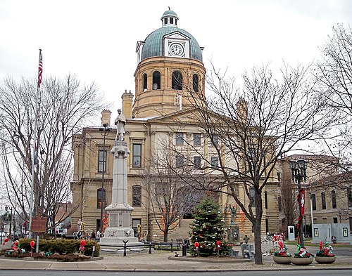
The Pennsylvania Railroad Depot and Baggage Room, located in Dennison, Ohio, is a highly significant historic site that represents the profound impact of the railroad industry on the development of Tuscarawas County. Constructed in 1873 by the Pittsburgh, Cincinnati and St. Louis Railroad (a subsidiary of the Pennsylvania Railroad), the depot served as the centerpiece of a major railroad division point and shop town. Featuring distinctive Victorian-era design elements with Gothic Revival influences, the wood-frame passenger station and adjacent brick baggage room reflect the standard, yet elegant, railroad architecture of the late nineteenth century. For decades, the depot functioned as a vital transportation hub, facilitating the movement of passengers and freight, and driving the economic growth of the region as a crucial stop between Pittsburgh and Columbus.
Beyond its architectural and early industrial merits, the depot achieved national prominence during World War II as the home of the famous Dennison Depot Salvation Army Servicemen's Canteen. Operating from 1942 to 1946, the canteen was staffed by approximately 4,000 local volunteers who worked around the clock to provide free food, coffee, and a welcoming environment to over 1.3 million service members traveling on troop trains. This extraordinary effort earned Dennison the nickname "Dreamsville, U.S.A." from soldiers who remembered the depot as a beacon of warmth and hospitality during a time of global conflict. Today, the beautifully restored depot, which has also been designated a National Historic Landmark, stands as a powerful monument to American homefront volunteerism and the enduring legacy of the nation's railway heritage.
Historic Significance:
Event, Architecture/Engineering
Architect, builder, or engineer:
Unknown
Architectural Style:
No Style Listed
Area of Significance:
Art, Agriculture, Architecture, Landscape Architecture, Commerce, Religion
Period of Significance:
1875-1899, 1850-1874, 1825-1849, 1800-1824
Historic Function:
Commerce/Trade, Domestic
Current Function:
Commerce/Trade, Domestic
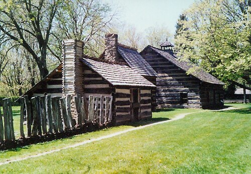
Established in 1817, the Zoar Historic District is nationally significant as the site of one of the most successful and longest-lasting communal societies in American history. Founded by the Society of Separatists of Zoar, a group of German radical pietists who fled religious persecution in Wrttemberg, the community was led by Joseph Bumler (later Bimeler). To ensure their collective survival in the Ohio wilderness, the members formally adopted a system of Christian communalism in 1819, pooling all land, labor, and assets. For over eighty years, the society thrived as a self-sufficient agrarian and industrial enclave, producing its own goods, operating its own mills, and even securing its financial independence by helping to hand-dig the nearby Ohio and Erie Canal. The commune successfully balanced spiritual devotion with economic prosperity until its eventual dissolution in 1898.
Today, the district stands as an exceptional representation of 19th-century communal planning and German-American vernacular architecture. The village preserves dozens of historic structures characterized by traditional German timber-framing (Fachwerk), locally fired red-clay roof tiles, and elements of the Federal and Greek Revival styles. At the heart of the village lies the Zoar Garden, a meticulously restored, geometrically arranged public garden designed to reflect the New Jerusalem described in the biblical Book of Revelation. Due to its extraordinary integrity and its profound contribution to the history of American utopian societies, the Zoar Historic District was designated a National Historic Landmark in 2016, offering an unparalleled window into the cultural, religious, and economic life of a devout immigrant community.
Historic Significance:
Information Potential, Event, Architecture/Engineering
Architect, builder, or engineer:
Unknown
Architectural Style:
Georgian
Area of Significance:
Historic - Non-Aboriginal, Industry, Agriculture, Architecture, Commerce, Landscape Architecture, Religion
Cultural Affiliation:
19th Century Seperatist
Period of Significance:
1875-1899, 1850-1874, 1825-1849, 1800-1824
Historic Function:
Domestic
Current Function:
Domestic
The Zoar Historic District, expanded by the 1975 boundary increase (Reference #75002124), represents one of the most significant and long-lived examples of a 19th-century communal society in the United States. Founded in 1817 by a group of German religious dissenters known as the Society of Separatists of Zoar, the community fled Wrttemberg to escape conscription and religious oppression. Faced with severe economic hardships in the Ohio wilderness, the group adopted a system of Christian communalism in 1819, pooling their property and labor to ensure survival. This cooperative structure allowed Zoar to flourish for nearly eighty years, during which the industrious society built a portion of the Ohio and Erie Canal, operated successful iron foundries, mills, and textile shops, and achieved near-total economic self-sufficiency before formally dissolving in 1898.
Architecturally and culturally, the expanded historic district preserves an extraordinarily cohesive collection of German vernacular buildings and landscapes that physically manifest the Separatists' utopian ideals. The district is characterized by its distinctive timber-framed, brick, and stone structures, many of which originally featured hand-pressed red clay roof tiles and traditional German construction techniques. At the geometric center of the village lies the Zoar Garden, a large public garden meticulously planned according to biblical symbology representing the New Jerusalem. The 1975 boundary increase expanded the original 1969 designation to encompass additional agricultural lands, industrial ruins, and outlying structures that were vital to the society's self-contained economy. Today, the district stands as a remarkably intact physical record of German-American immigration, communal planning, and early Midwestern industrial history.


